Farmers Guardian
by John Wilkes
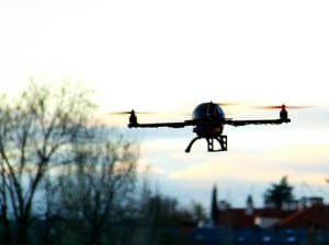 |
Like their counterparts in Europe, farmers in the United States see potential for the use of Unmanned Aerial Vehicles (UAVs) in their businesses. However, a ban on the use of drones for commercial purposes is preventing any further development of the technology in agriculture from, quite literally, getting off the ground.
The agricultural sector featured strongly at the UAS (Unmanned Aerial Systems) Commercialisation Industry Conference held in Washington, DC, at the end of last year.
As of June 13, 2014, crop research with UAVs at American universities became more complicated. Research must now have an aviation sector focus to be legal. On June 18, 2014, the Federal Aviation Authority (FAA) also stopped all UAV flights over agricultural land for economic purposes without operators first obtaining a ‘333 Exemption’ (Special Rules for Certain Unmanned Aircraft Systems).
Anyone can fly a UAV as a ‘hobby’ but they are prohibited from using machines for the purposes of making management decisions.
So, ‘viewing a field to determine whether crops need water when they are grown for personal enjoyment’ is permitted but ‘determining whether crops grown as part of a commercial farming operation need to be irrigated’ is not permitted. If a UAV has gathered the data, decisions around agchem, fertiliser and pesticide applications are completely off the radar.
Any commercial use qualifies UAVs as aircraft, subjecting those who employ them to more onerous caveats, via the FAA’s 333 Exemption, than hobbyist fliers. A qualified pilot, aided by a spotter, must fly the UAV, which itself must pass stringent Airworthiness Certification. Otherwise, both hobbyist and industry must respect other criteria set out for UAVs.
Potential providers of equipment, services and software across a raft of sectors, including the oil industry, public services, meteorology, journalism, logistics and photography, gathered at the conference to discuss the latest aerial observational technology.
Rulings
Overshadowing the discussions were the FAA rulings, which directly affect the development of UAVs in the commercial world. Penalties for regulation violations start with a US$10,000 (£6,600) fine and can lead to prison.
Jim Williams, of the FAA’s Unmanned Aircraft Systems Integration Office, could give the conference few answers and little hope of any imminent regulatory movement by the FAA. The US Government’s lack of funding for the FAA might go some way to explaining its limited ability to research areas of concern associated with the safe use of American airspace by this new and rapidly expanding technology.
The FAA will publish rules for comment this year, followed by implementation. Until then crop scouting and use of Near Infra Red (NIR) technology on some of the 66 million hectares of US soybean and wheat will have to wait, if it is to be performed by UAVs. The feeling at the conference was implementation might not happen until 2016, too late for the 2015 cropping year. In fact, 2017 would now seem a more realistic target for all concerned.
For those companies keen to develop and apply technology to large swathes of America’s farming acreage, which comprises 40% of all US land, the sense of disquiet at the conference was palpable. Factoring in currently only 5% of American crop farmers are using technology to make management decisions illustrates the size of the potential market.
Much of the frustration in the room was voiced by fourth generation Idaho grain farmer and precision agriculture and UAV pioneer Robert Blair, who spoke plainly and with purpose about his industry and its challenges.
He highlighted the strides taking place on large-scale South American and Australian arable operations as well as in the UK, all unhindered by excessive bureaucracy. There was a need for the US to up its game and maximise resources to keep parity and compete globally, he said. The US did not even rank in the UAV ‘friendly skies’ statistics – Brazil gets a 5/5 rating, Australia 4/5 and it is 3/5 in the UK, according to Mr Blair.
Yet despite the inertia, some companies are forging ahead, but with focus now shifting onto the gathered data – rather than its sourcing solely via UAVs.
Manned flights
Phil Ellerbroek, global sales director with RoboFlight, based in Greenwood, Colorado, told the conference, following this legislative setback, his company was now looking at manned flights in small light aircraft to gather images and data. Fewer constraints are placed on flight times and altitude, which may lower the cost per hectare for scouting and remote sensing for farm co-ops and neighbouring farmers using an aircraft for a few hours. Figures of about US$4-$10/acre (£6-£16/ha) for mapping/scouting were being bandied around, although price would depend on individual locations and likely yields, he said.
Gathered imaging and data was turned round quickly, normally within 24 hours, into the shape files which formed the basis of field prescriptions for agronomist’s crop recommendations. These files were fully compatible with most US farm management solutions, including Trimble’s Farm Works, Ag Leader’s SMS and SST’s Summit software.
Mr Ellerbroek cited an early piece of work: “We had two fields of 17ha side by side. On the first field we used a traditional agronomist prescription for flat rate application, on the second we used remote sensing and created an NDVI [Normalized Difference Vegetation Index] map and cross-referenced that to 12 soil samples and generated a prescription from that leading to a 30% nitrogen reduction and an $18/acre saving.”
Up in Madison, Wisconsin, Mike Hopke is an agronomy territory account manager with Landmark Services, a 15,000-member farmer cooperative servicing Southern Wisconsin and Northern Illinois. He is one of 30 agronomists responsible for about 364,000ha of corn, soybean, wheat and alfalfa. Harvest year 2014 was a good one in Wisconsin: corn yielded to 18t/ha; the wheat crop also came in better than expected at 5.3–6.7t/ha and soybean was up to 3.7t/ha.
Landmark has been employing UAVs for the past couple of years, on a no-charge basis to their customers, as part of their agronomy service. They credit a good growing season and assistance from this new technology for improved yields.
They do not use software for data analysis, but rely on visual image assessment to assess crops before following up with inspection conventionally on the ground. Even so weed outbreaks, crop emergence patterns, insect attack and drought stress can be flagged up and responded to more quickly than before. The clarity obtainable from low-flying UAV imagery post-crop emergence enabled weeds species identification and assisted herbicide selection, Mr Hopke said.
Landmark is just one of many US agronomy businesses looking to expand its services, but will not do so until there is more clarity from the authorities.
“The more technology and software analysis which develops, the more time we will save exponentially, but for now we are not investing.”
As the range of potential benefits for America’s farmers from UAV technology continues to grow, the agricultural industry needs someone with a seat at the administrative high table, like Robert Blair, for farming’s voice to be heard loud and clear. UAV use needs expediting, unhindered by unrealistic, onerous regulation; otherwise America is going to be left trailing behind crop-producing powerhouse nations which have embraced this new and innovative technology.
Case study: Robert Blair, Three Canyons Ranch, Idaho
Robert Blair started down the precision agriculture route at 526ha Three Canyons Ranch in Kendrick, Idaho, in 2003. This led to his pioneering UAV experimentation in 2006, and to him becoming International Precision Farmer of the Year in 2009. Scholarships followed, allowing for studies across the world. A passionate advocate of the technology, he says: “In 2004, I took a flight over my land, and it just all made sense – the ability to actually see the crop and areas of stress in real-time – it was a no-brainer.”
Use of UAVs took precision agriculture to a new level on the farm. Being able to stitch multiple-imagery together and then overlay yield mapping with NIR imagery opened up many more possibilities. On a purely practical level, while deep canyons split the farm, fields an hour’s tractor ride away are actually very close – in a straight line.
“Using UAVs, the journey to start scouting those crops takes me a couple of minutes,” says Mr Blair.
This all contributes to tight controls on inputs. Three Canyon’s three-year rotation of hard and soft winter/spring wheat, followed by malting barley or spring wheat with a legume break crop – marrowfat peas, lentils or garbanzo beans (chick peas) afford a rolling yield average for wheat of 100 bushels/acre (6.7t/ha).
Weed control has been a significant beneficiary from aerial surveillance. Identification of wild oats and goat grass allows hand rogueing, while perennials such as Canadian thistle and morning glory can get spot strategic applications with herbicide.
The impact of crop damage from the local elk population can also be monitored easily during the growing season. Issues with claims under the federal farm crop insurance scheme are greatly simplified with relevant evidence obtained from the air when, for example, severe weather conditions make on-land assessment difficult. Federal crop insurance is now applicable for 89% of all insurable farmland in the US.
Current FAA rules require drones must:
- Be kept below 121.92 metres (400ft)
- Remain within half a mile of the pilot and always in visual line of sight
- Weigh under 55lbs (25kg) weight
- Not be flown within five miles of an airport
- Be flown for no more than 30 minutes at a time