Mashable
by Andrew Freedman
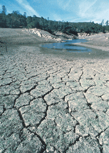 |
Forget about the possibility that a single “atmospheric river” storm could end California’s worst drought in at least 1,200 years, NASA researchers said Tuesday.
Instead, it will take 11 trillion gallons of water, which is one and a half times the capacity of Lake Mead, Nevada, the country’s largest reservoir, to climb out of the water deficit the Golden State is in, new data shows.
The NASA analysis comes from satellite and aircraft-based measurements of groundwater and mountain snowpack in California, and was released at the annual meeting of the American Geophysical Union in San Francisco on Tuesday morning. The data also comes a week after a severe storm hit California, dumping more than nine inches of rain in some places, and just before another storm hits central and northern California.
“It takes years to get into a drought of this severity, and it will likely take many more big storms, and years, to crawl out of it,” said NASA’s Jay Famiglietti in a NASA press release.
NASA claims the calculation of the volume of water required to end a drought is unprecedented, and was made possible by a set of satellites collectively known as the Gravity Recovery and Climate Experiment, or GRACE. Other data came from airborne measurements of mountain snowpack using NASA’s Airborne Snow Observatory (ASO).
Previously, the same research team from NASA’s Jet Propulsion Laboratory (JPL) in Pasadena, California, showed that water storage in the state’s Sacramento and San Joaquin river basins was 11 trillion gallons below typical seasonal levels, a figure that has steadily grown larger since GRACE satellites launched in 2002. These river basins lost a volume of about four trillion gallons of water each year since 2011, the data shows, with the vast majority of this lost in California’s Central Valley.
To put this annual amount into perspective, it is more water than California’s 38 million residents use for domestic and municipal uses, NASA said.
Speaking at a press conference, Famiglietti said the Central Valley of California — one of the most agriculturally productive areas in the U.S. — has lost a Lake Mead’s worth of water since 2011. (Lake Mead itself has reached record lows in recent years.) The Sacramento River and San Joaquin River basins, Famiglietti says, have lost one and a half times Lake Mead’s capacity of 36 million acre-feet, or about 12 trillion gallons, in just the past three years.
He says the recent rainstorms improve conditions on the surface, where soil moisture is improving, but groundwater in aquifers beneath the Central Valley will take far longer to refill. “The groundwater takes much longer to respond,” Famiglietti said. He compared the long-term decline in the Central Valley’s groundwater to a tennis ball bouncing down a flight of stairs — there are temporary bounces when rain is plentiful, but high water demand is ensuring that the overall direction is downward.
The results show that the 2014 snowpack in the state’s Sierra Nevada mountain range was the lowest on record, beating out the previous record-holder of 1977, when the state had half the population than it does now. The ASO data show that previous data based solely on ground observations had miscalculated the snowpack and the water running off of the snow pack when it melts, and the new numbers are half of the previous estimates.
According to NASA’s Tom Painter, the low snow extent contributed to the unusual warmth in California during 2014, as the year is likely to be the state’s warmest since records began in 1880.
Painter said scientists used two main instruments mounted to a De Havilland Twin Otter aircraft to measure how much water is in the snowpack and how much light the snow absorbs, both of which influence how much water will flow out of a basin when the snow melts and into area reservoirs and rivers. One of the instruments is known as a LIDAR, which is mounted on the belly of an aircraft. This acts as a “high-frequency laser pointer,” Painter said. The other instrument is an imaging spectrometer, which detects reflected light from the snow.
The GRACE satellites help measure Earth’s changing shape, surface height and gravity field, and allow scientists to measure groundwater based on very subtle shifts in the planet’s gravitational field.
New drought data shows the groundwater levels in the Southwest U.S. are in the bottom 10% since such records began in 1949, reflecting increased drawdowns of these resources by farmers and other water users, as well as the influence of droughts.
The GRACE satellite mission is already operating beyond its designed lifespan, with a new satellite system planned for launch in 2017. Famiglietti and his colleagues at NASA are hoping the current satellites manage to eek out another few years without disrupting the data.